采用先进信号处理技术进行云测量


概览
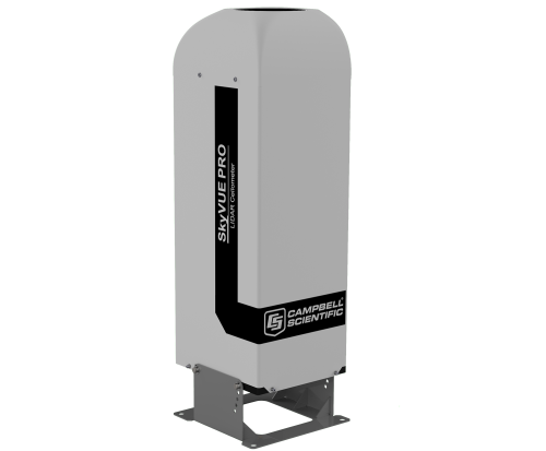
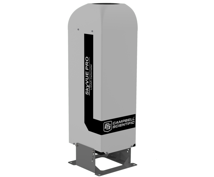
SkyVUE™PRO 激光雷达云高仪可测量云高和垂直能见度,用于气象和航空应用,是需要高细节的长期研究应用的理想选择。
其坚固的结构非常适合长期安装,因为它只需要很少的维护,并且具有独特的层积云校准程序,允许在现场校准云高仪。
SkyVUE™PRO 符合CAA, WMO, and ICAO 指导,符合或超过所有建议和规范,包括 CAP437, CAP670, and CAP746。
SkyVUE™PRO 的报告范围为10公里,易于使用,拥有先进的信号处理和独特的光学配置,可提供卓越的分辨率和性能。
SkyVUE™PRO 有许多标准功能,从用于自动校正云层高度的倾斜底座和双轴倾斜仪,到加热器、鼓风机和可在任何条件下运行的太阳过滤器,使其能够在世界各地部署。
独特的标准功能包括易于操作的层积云校准、长寿命备用电池和双时钟,以增强其许多连续诊断自检,并确保连续、可靠和准确的性能。
优势与特点
- Single-lens design for high signal-to-noise ratio and maximized detector sensitivity, resulting in greater performance at low and high altitudes
- High performance and high specification at a competitive price
- Tilt angles to 24°, improving performance during precipitation events and reducing impact of solar glare
- Unique continuous comparison of two separate internal quartz clocks to ensure measurement confidence
- Mixing layer height assessment option for air-quality applications
- User-friendly stratocumulus calibration capability and easy test with a calibrator plate provided as standard for easy field calibration
图像
相似产品
技术说明
The SkyVue PRO LIDAR ceilometer measures cloud height and vertical visibility for meteorological and aviation applications or long-term research applications where a high level of detail is required. Using LIDAR (LIght Detection And Ranging) technology, the instrument transmits fast, low-power laser pulses into the atmosphere and detects backscattered returns from clouds and aerosols above the instrument.
A unique, efficient single-lens design increases optical signal-to-noise ratio and allows for larger optics in a compact package, improving accuracy and measurement performance. The optics are immune to damage from direct sunlight.
This approach, along with state-of-the-art electronics, provides a powerful and stable platform from which to measure cloud height and vertical visibility to high accuracy. The SkyVue PRO measures the atmosphere with high stability and repeatability, delivering excellent performance in even the harshest of conditions.
The SkyVue PRO provides information on cloud height, sky condition (up to five layers), vertical visibility, and raw backscatter profiles to a range of 10 km.
An automated Mixing Layer Height (MLH) option is available for air-quality applications. MLH is an important parameter in modelling air quality and air pollution episodes. The MLH is determined based on the operational algorithm used by KNMI, which detects the top of boundary layers.
The algorithm runs within the SkyVue PRO itself, and the results are incorporated in data messages, making it easy to incorporate the MLH into whatever systems are already in use without the need to run external special software. If you require the MLH option, please contact us.
The unique stratocumulus calibration capability, which allows users to calibrate measurements of scatter coefficients, uses a simple and user-friendly field method, giving complete confidence in the scatter profiles reported and removes the requirement to have the unit sent back for calibration.
Reliable range measurement is further assured by cross-checking two separate internal quartz clocks, eliminating the possibility of unidentified errors due to clock drift.
The SkyVue PRO can be tilted at various angles up to 24°. A small tilt is important, as it allows the ceilometer to resist high levels of reflection from large raindrops and frozen particles that can impair vertical-type sensors. The tilt also improves rain run-off on the ceilometer window, resulting in a much higher performance compared with vertical ceilometers.
Tilting to 24° also means that it can be operated anywhere in the world without the sun shining into the lens and resulting in missing data. An internal two-axis inclinometer provides automatic correction of cloud height at all angles, ensuring ease of installation and confidence that cloud heights are automatically corrected throughout the lifetime of the installation.
Software for data visualization and interpretation
Ceilometer data can be displayed using Campbell’s Viewpoint software or fed directly into existing data systems. The Campbell Viewpoint software will display the output from the ceilometer in a convenient and configurable form, including information on sky condition, mixing layers, and scatter profiles. All can be displayed simultaneously or separately with ranges and time scales. For more information on Viewpoint click here.
产品规格
| Dimensions | 100 x 32.7 x 28.1 cm (39.4 x 12.9 x 11.1 in.) including base |
| Shipping Dimensions | 120 x 45.0 x 45.0 cm (47.2 x 17.7 x 17.7 in.) |
| Weight | 32 kg (71 lb) without cables |
| Shipping Weight | 58 kg (127.9 lb) |
Instrument Performance |
|
| Reporting Range | 0 to 10 km (0 to 33,000 ft) |
| Minimum Reporting Resolution | 5 m (16.4 ft) |
| Hard Target Range Accuracy | ±0.25%, ±4.6 m (15.1 ft) |
| Reporting Cycle | 2 to 600 s |
| Cloud Layers Reported | Up to four layers |
| Sky Condition | Up to five layers with cover in oktas according to WMO requirements for SYNOP and METAR codes as standard |
| Vertical Visibility | Reported when no clouds selected |
| Laser Wavelength | 912 nm (±5 nm) |
| Eye Safety Standard | Class 1M |
Electrical Specification |
|
| Power Source | 110, 115, 230 Vac ±10%, 50 to 60 Hz, 470 W maximum |
| Battery |
Internal 12 Vdc, 2 Ah battery backup Provides 2 h measurement, without blower/heater, in the event of mains failure. |
| Interfaces |
|
| Laser Safety Compliance | EN60825-1:2001 |
| Electrical Safety Compliance | EN61010-1 |
Environmental Specification |
|
| Temperature Range |
|
| Humidity Range | 0 to 100% RH |
| Maximum Wind Speed | 55 m/s (123 mph) |
| IP Rating | IP66 (NEMA 4x) |

下载
SkyVue Example Programs v.1 (3 KB) 07-11-2019
CRBasic data logger programs for use with CS message 1. One example includes a cyclic redundancy check (CRC).
Please contact support for help with programming to read other message types.
SkyVue PRO-CS135-OS v.14 (429kb) 11-12-2019
Campbell Scientific has introduced a new operating system, OS14 for the SkyVue PRO and CS135 ceilometer. It is fully backwards compatible. OS14 is available free of charge and can be downloaded from the Campbell Scientific website or supplied by email on request.
Upgrade to OS14 is recommended.
Improvements
OS14 has introduced improvements to overlap functions, cloud detection filters and thresholds to reduce false cloud detection at low and medium heights notably to about 1,000m.
OS14 has increased low level vertical visibility performance and stability particularly from the ground to 50m.
An option “cloudMode A“ has been added to only report the highest cloud seen during precipitation events. This has been added to further minimise the reporting of rain as low cloud.
OS14 has a new command “application n”, which allows the user to select the recommended, optimum settings for specific applications, including Aviation, Research, Air Quality and Meteorology. In addition, you can specify you own user defaults or select the original default settings for all settings as defined in earlier operating systems. OS14 is pre-configured for Meteorological use in newly purchased SkyVue PRO sensors or when OS14 is loaded onto a SkyVue PRO or CS135 running earlier operating systems. Individual user settings remain adjustable for further optimisation by the user and for use in other applications.
There is a new option to allow the user to select whether backscatter rolling averages are calculated as mean or median values. The median option is new and is more effective at removing transient signals caused by birds and insects. A new parameter has been added in the BS command to permit users to select either option. Other commands affected include “getuser” and “setuser”.
A “mainsFail” flag has been added to the output messages to indicate failure of mains power whilst operating on the backup battery.
OS14 has introduced a global ID (address) of “99” to permit users to connect to the instrument over a serial connection, if the ID is unknown.
A command “loados” has been added to make it easier to load a full new operating system. The selection of specific individual board operating systems, DSP, TOP and PSU, can still be performed and “loados 4” will continue to function, as in previous OS versions.
OS14 now has a wider range of height offsets to allow greater correction of the height of the sensor than previous OS versions.
Fixes
OS14 includes changes to Sky Condition to improve weighted average cloud heights and prevent the small possibility for arithmetic overflow which may result in a spurious layer being reported.
OS14 also includes improved backscatter filtering to reduce the possibility of noise banding when observed with Viewpoint
OS14 supersedes OS13 which had the above features and includes further optimised control of the dirty windows LED.
Campbell Viewpoint v.2.1.0.2 (86 MB) 09-10-2019
Campbell Viewpoint is viewing software designed to accompany the Campbell Scientific optical sensor range, including the CS135 ceilometer, SkyVue PRO, SkyVue 8, SkyVue 8M, CS120A visibility and CS125 present weather sensors. It is free to download (or via email on request) and use for 100 hours, after which you will need to purchase a key to continue using it.
Version 2.1.0.2
Viewpoint version 2.1.0.2 has introduced our new ceilometer sensors to the list of instruments that can be monitored. This includes the SkyVue PRO, SkyVue 8 and SkyVue 8M.
Previous sensors are still available.
Version 2.1.0.2 also includes some minor bug fixes and improvements to the help menu.
常见问题解答
SkyVue PRO: 1
-
The cloud ceiling height relates to the height of the base of the cloud where the sky is overcast or has broken cloud cover.