
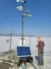
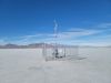
The Utah Geological Survey, supported by the Utah Division of Water Rights, has constructed a network of eddy-covariance stations across Utah to measure evapotranspiration. These stations measure the combined water evaporation from land and water transpiration by plants. Consumptive use—the water absorbed and transpired by plants—contributes significantly to evapotranspiration in vegetated areas, including croplands.
For water managers in Utah to accurately determine the water conserved or used by agricultural practices, there is a vital need for improved ground truth measurement of water use in the state. The Utah Flux Network’s (UFN) objective is two-fold: to use the eddy-covariance method to measure evapotranspiration in the field, and then use that data for comparison with measurements gathered by satellite. To this end, the UFN has set up four eddy-covariance stations to date, with more to come.
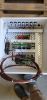
These stations are built from a core set of research-grade instrumentation. Each station includes the following:
- Data logger (CR1000X or CR6)
- Gas analyzer with integrated sonic anemometer (IRGASON™)
- Temperature and relative humidity probes (EE181)
- Four-way net radiometer (NR01)
- Soil heat flux plates (HFP01)
- Soil temperature sensors (TCAV)
- Soil moisture sensors (CS655 and SoilVue™10)
- Mechanical anemometer and wind vane
- Photosynthetically Active Radiation (PAR) sensors
- Solar power system
Each station precisely measures the movement of water vapor, CO2, and energy in and out of the station’s local upwind footprint. Net radiometers and soil sensors are used to study energy balance and soil heat flux. All these instruments are highly accurate, and many of them can capture measurements at an extremely high rate.
Several new stations will soon be installed, including one at the Nature Conservancy’s Dugout Ranch in San Juan County, Utah. The new stations were carefully designed in collaboration with Campbell Scientific's application engineers and then meticulously built and packaged by Campbell Scientific's Manufacturing and Client Services teams. Because the stations were prewired and preprogrammed, the UFN can expedite the network deployment.
The UFN currently provides data to AmeriFlux, FLUXNET (international climate data network), and MesoWest. Data from the UFN also aids long-term water conservation and management strategies, such as water banks. Both the Price Water Bank Pilot Project (which converts conserved agricultural water into instream flow near Price, Utah) and the administration of the Colorado River Compact (which measures consumptive use in the Upper Colorado Basin) use data from the UFN. Measurements gathered from the UFN can also be used for hydrologic and climate models, as these stations measure important atmospheric components, including carbon dioxide (CO2), water (H2O), and available energy.
案例总结
应用
Improving ground-truth measurement of water throughout the state位置
Utah, USA使用的产品
CR1000X CR6 IRGASON EE181 NR01 HFP01 TCAV CS655 SoilVue 10 RV50X参与机构
Utah Geological Survey, Utah State University, Central Utah Water Conservancy District, Colorado River Authority of Utah测量参数
Water vapor (H2O) flux, carbon dioxide (CO2) flux, sensible heat flux, net radiation, soil heat flux, energy balance, temperature, humidity, wind speed, wind direction相关网站
Utah Flux Network website查看PDF